Our Team – Water
Current Ph.D. Students
My research is focused on terrestrial and aquatic processes that influence the recovery of subarctic lakes impacted by mining pollution. We use a variety of techniques across the disciplines of hydrology, biogeochemistry and limnology to measure fluxes of contaminants (mostly arsenic and antimony) within subarctic watersheds. These types of information are useful so that we can better predict the long-term fate of contaminants in northern environments. I have been living and working in the Northwest Territories for the past 12 years and much of my work has been in collaboration with local communities and aboriginal organizations. I am currently supported by the W. Garfield Weston Foundation, the Ontario Graduate Scholarship program, the NWT Cumulative Impact Monitoring Program, and the Aurora Research Institute Fellowship Program.
Co-supervised with John Chetelat (Environment and Climate Change Canada)
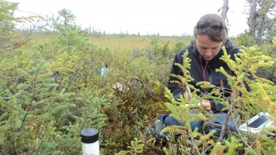
My research aims to develop a deeper understanding of interactions between vegetation structure and composition, and hydrologic regimes of forested wetlands in temperate region, using field-based measurements and high resolution remote sensing data (LiDAR data, and UAV-based multispectral imagery). During the summer and fall of 2017, I visited over 60 wetland sites in Gatineau Park, to assess their general hydrology and vegetation characteristics for potential inclusion in this research. In 11 representative samples of forested wetlands, a total of 15 wells (equipped with pressure transducer) and 27 piezometers were installed to measure water levels and physiochemical properties of groundwater during the summer and fall of 2018/19. In the same sites, vegetation attributes are being measured using direct techniques such a clinometer for tree height, and indirect techniques such a skyward digital hemispherical photography to estimate canopy openness and leaf area index. Airborne LiDAR data, available at Carleton University, are being used to extract vegetation and topographic information. UAV surveys are planned to be conducted during the leaf-on period of 2019. Statistical techniques such as regression and multivariate gradient analysis will be implied for data analysis.
Co-supervised with Doug King
Current MSc Students
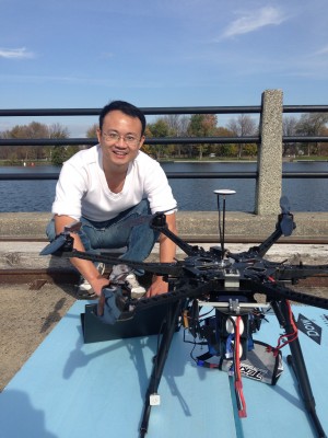
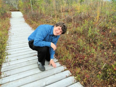
My research is focused on snowmelt modelling in the Niaqunguk watershed in Iqaluit, Nunavut. A hydrological model of snowmelt will be built using the Raven hydrological modelling framework. This model will incorporate a variety of water balance components including snow, rain, evapotranspiration, sublimation and surface flow collected from micrometeorology towers located around the watershed. Snow depth and extent will be measured using structure from motion (SfM) with multi-temporal flights from a remotely piloted aircraft system (RPAS) and extensive field surveys. The model will be used to model paths and quantity of waterflow within the watershed which will help the City of Iqaluit in planning and managing their freshwater resources.
Former Lab Members
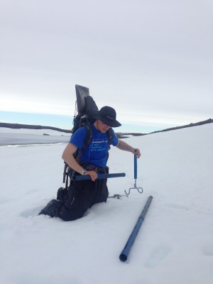
My research is focused on how we determine the amount of water stored as snow across a landscape at the end of the winter. To determine the amount of water in snow you have to measure the snow depth and the snow density. Working near the northern treeline at the end of winter we use ski-planes and helicopters to travel across large areas measuring and modelling the amount of snow on the ground. Knowing how much water has been stored over the winter gives an indication of the how much water will be available in the spring. My research is done in conjunction with the Northwest Territories Government and the Northwest Territories Power Corporation. I live in Ottawa, Ontario, just down the road from Carleton University. My background is in mechanical engineering.
Status: Complete
Status: Complete
I use a wide variety of remote sensing, GIS and statistical techniques to study peatland hydrology in temperate and sub-arctic Canada. At the Debeers Victor Mine (northern Ontario) and the Alfred Bog (eastern Ontario) I am developing methods to monitor changes in peatland water table and soil moisture using Synthetic Aperture Radar (SAR). In addition to SAR I am also using UAV imagery and LiDAR data to build 3D models of the surface and vegetation within the peatland to help in better understand the variability we see in the SAR. I also have been collaborating with Canadian Forest Service research scientists in Wood Buffalo National Park (NWT/AB) to use SAR to map wetlands over very large extents. I spend a lot of time during the spring, summer and fall at these three sites collecting as much field data as possible in order to analyze the remotely-sensed responses.
Status: Complete
Co-supervised by Doug King and Murray Richardson
Status: Complete
I am a second-year M.Sc. student studying snow hydrology in the area around Iqaluit, Nunavut. Iqaluit currently draws drinking water from the nearby Lake Geraldine, but this supply will soon be outstripped by the city’s rapidly growing population. As a result, the city council has identified water security as an issue of critical concern in all future municipal planning. A potential secondary water supply has been identified in the nearby Apex River, which could be used to supplement Lake Geraldine. Streamflow in this region is dominated by inputs of snowmelt, but snow accumulation and redistribution are not easily predicted, due to the complex interaction of rugged terrain and powerful winter winds. Through the use of extensive field surveying, microclimatic monitoring, and digital terrain analysis, I am developing an improved snow accumulation and melt model for the Apex River watershed. This effort will improve our understanding of snow hydrology in the Eastern Canadian Arctic, and eventually support community decision making for drinking water supply and renewable power generation.
Status: Complete
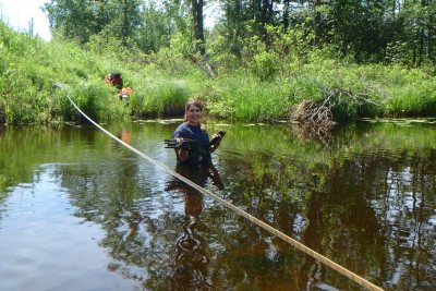
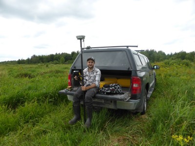
I am a second-year M.Sc. student studying groundwater and surface water interactions using environmental tracers in the Jock sub-watershed, located outside the Ottawa city center. I am interested in determining the spatial and temporal variability of groundwater contributions to streamflow at the catchment scale. This catchment is of particular interest due to the mixed land use, heterogeneous soil composition/deposition and fractured bedrock terrain. Throughout the year, I was busy collecting spatially and temporally variable samples of end-members: groundwater, snowmelt, precipitation, soil water and stream water, for isotopic and geochemical analysis. I plan on using end-member mixing analysis (EMMA) to determine variability of groundwater contributions to streamflow throughout the watershed. I am also using standard hydrometric techniques such as baseflow separation to enhance EMMA results. More often than not you will find me out in a stream measuring discharge or back in the lab measuring alkalinity and silica.
My thesis applied a multidisciplinary approach to examine long-term anthropogenic assessments on domed peatlands, using Alfred Bog (a 7100 year-old domed peatland complex in southeastern Ontario) as a case-study. The study reconstructed changes in areal versus volumetric reduction, impacts of anthropogenic drivers and supply of three ecosystem services (ESs) (carbon storage, food production, peat production) over 11 dates covering 200+ years (1800-2014). Diverse historical records (air photos, maps, texts) were collected, processed and interpreted to map and quantify changes in GIS. Findings included that the area versus volume diverged, not only for the peatland’s reduction as a whole but also when examining the impacts of individual drivers. The magnitude of this divergence varied both between examined drivers and dates, as their distribution across the depth profile changed. Despite greater areal losses in the 1800s, deeper disturbances in the 1900s yielded greater volumetric changes. This paralleled the shift from agricultural conversion to commercial peat extraction, underscoring their distinct and temporally dynamic effects on ES supply. Shorter intervals helped identify changing relationships between ESs and drivers, and broader human-environmental interactions. Thus, detecting spatial and temporal variations in ES responses to disturbances within domed peatlands necessitated multidimensional analyses.
Status: Complete
Co-supervised with Mike Brklacich
During my time at Carleton I completed two undergraduate degrees contributed to many different field work projects such as mercury levels in fish in Gatineau Park (Quebec), soil moisture, vegetation densities and streamflow in Alfred Bog (Ontario) and on a permafrost borehole drilling campaign in Northwest Territories. I also completed my MSc. in Geography. My thesis involved researching and developing a hydrological model for Jock River watershed in the Ottawa area. The model was built using the RAVEN modelling framework and was used to model future climate change scenarios. The model required a large amount of data that had to be identified and assembled, such as soil and vegetation information, terrain morphology, historic time series data (hydrological and climate). These data were collected either in the field or through a variety of other sources. My research also allowed me to take a field course in the mountains and to make connections with conservation authorities, different universities and several government agencies.
Status: Complete
Co-supervised with Scott Mitchell