The recovery of Yellowknife area lakes from 50 years of mining pollution

Yellowknife is located in the subarctic Canadian Shield on the northern shore of Great Slave Lake in the Northwest Territories, Canada. Thousands of small lakes are scattered across the landscape of the region, left over from the retreat of the Laurentide ice sheet and the recession of Glacial Lake McConnell less than 10 000 years ago. These lakes are important culturally for local indigenous and non-indigenous people who use these resources for subsistence and recreational purposes.
The mining and exploration industries are an important part of the social and economic fabric of Yellowknife. Historically, the region has been one of the most productive gold mining regions in Canada and more than 13 million ounces of gold were produced in the area between 1938 and 2004. The early years of mining activities (pre-1958) resulted in the release of large amounts of arsenic, antimony, and metals to the surrounding area via atmospheric emissions from the roasting of the ore that was being mined. Sixty years after the bulk of these emissions were deposited large amounts of arsenic and antimony remain in lake sediments and soils in the region, and surface waters of many small lakes continue to have elevated concentrations of these contaminants. A persistent question on the minds of local communities, governments and resource managers is “why are concentrations of arsenic and antimony still elevated in local lakes and will these concentrations decrease over time?”
This project was developed in collaboration with Dr. John Chételat (Environment and Climate Change Canada) and Dr. Heather Jamieson (Queen’s University) (http://www.queensu.ca/geol/jamieson) to help address long-standing concerns about the chemical recovery and long-term fate of arsenic in lakes of the region. We are also contributing to the broader understanding of the mobility of arsenic and antimony in northern environments, which is relatively understudied compared to the large amount of research that has been directed at other contaminants, such as mercury and lead.
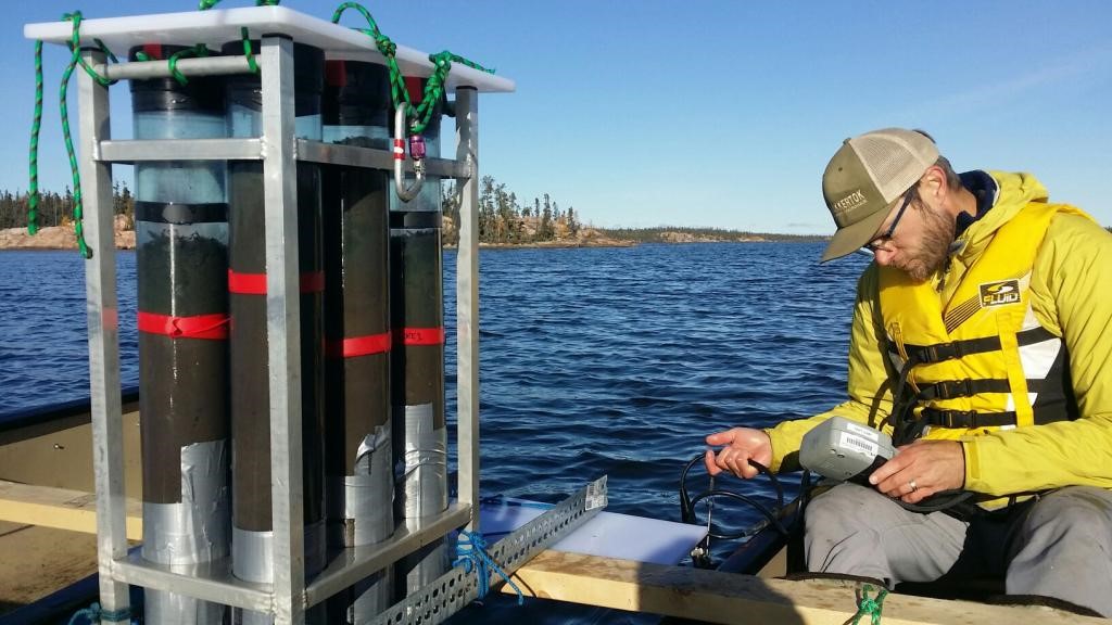
We are using a variety of tools from the disciplines of biogeochemistry, limnology, and hydrology to develop our understanding of the fluxes of contaminants between different landscape environments. Much of our work is focused on the watershed of Lower Martin Lake, a small lake close to Giant Mine (the largest source of arsenic and antimony emissions in the region). High frequency year-round sampling is being used to partition the various fluxes of arsenic and antimony across the watershed. Inputs and outputs of arsenic from the lake are measured by combining bi-weekly chemical sampling and continuous flow measurements at the lake inflow and outflow. The flux of arsenic between lake sediments and the overlying water column is measured using a combination of porewater extraction techniques and experimental field incubations of lake sediments (Figure 1).
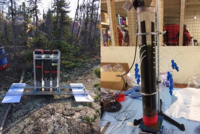
Figure 1. Two different methods used to measure the flux of contaminants between lake sediments and overlying waters. On the left is a sediment incubation experiment, which is described in more detail in the following figure. On the right is an example of sediment porewater sampling using an in-situ extraction technique. By combining these methods we are able to measure the flux of contaminants between sediments and overlying waters and also explore the biogeochemical processes that are occurring within the sediment porewaters.
 The contribution of arsenic from surface runoff from the surrounding catchment is estimated in a small subcatchment by measuring discharge volume and chemistry from the catchment (Figure 2). Contemporary atmospheric loading of arsenic to the watershed is measured in summer and winter by collecting rain and snow for chemical analyses.
Seasonality is an important feature of subarctic environments and early results from this study show that the mobility of arsenic varies across different parts of the landscape and is seasonally dependent. Lake sediments are a small source of arsenic to overlying waters during the open-water season when lake waters are well-oxygenated. These sediments become a substantial source of arsenic by mid-winter once anoxic conditions develop in the water column and the concentration of arsenic in lake waters increased almost three-fold compared with late summer measurements (September: 50 µg/L – April: 141 µg/L). Lake water arsenic concentrations decreased rapidly to less than 40 µg/L once snowmelt entered the lake but prior to the loss of ice cover and peak freshet at the lake outlet (Figure 3). Terrestrial contributions of arsenic to the lake via surface runoff were isolated to the snowmelt period in early May and during record precipitation periods in June and July. Loading estimates during these periods indicate that substantial amounts of arsenic continue to be transported from the terrestrial to aquatic environment.
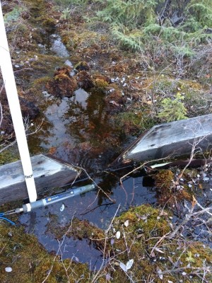
Figure 2 Terrestrial runoff is measured in a small subcatchment using standard V-notch weirs. Combining the discharge data with regular chemical sampling allows us to estimate the transport of contaminants from terrestrial to aquatic environments.
These observations highlight the importance of considering processes across seasons in evaluating the long-term fate of arsenic in shallow lakes in the region. The annual remobilization of sediment arsenic into overlying waters under ice may be a significant process inhibiting the long-term chemical recovery of mine-impacted shallow lakes since it does not coincide with periods of high flow at lake outlets. Large winter increases in lake water arsenic also suggest that winter processes should be considered when evaluating exposure of aquatic life to legacy arsenic.
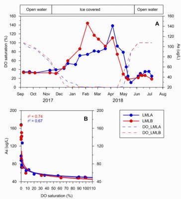
Figure 3: Two figures showing the importance of seasonality on the concentration of arsenic in small lakes impact by mining pollution in the Yellowknife area. A) Surface water As concentrations and dissolved oxygen levels near the sediment boundary in Lower Martin Lake, September 2017 – July 2018; and B) the relationship between surface water As and dissolved oxygen over the same period. Surface water As concentrations represent the depth-weighted average. Depth at sampling locations is approximately 2m. LMLA and LMLB represent two separate sampling locations in the lake. Dissolved oxygen levels are measured within 20 cm of the sediment boundary.
Support, partnerships and collaborations
This project was developed in collaboration with the Yellowknives Dene First Nation (YKDFN) and we have provided more than 20 person days of employment and training to YKDFN members during the first year of this project. Our goal is to contribute to the development and training of local indigenous field assistants that can be employed by other researchers working in the region. We are a long way from accomplishing this but look forward to continuing this work.
We work closely with the Chief Public Health Officer of the NWT and the Department of Health and Social Services. Data generated from our work was used by the health department to develop a public health advisory for recreational activities near certain local lakes in the region to limit public access to areas with high concentrations of arsenic in soils and lake waters (https://www.hss.gov.nt.ca/en/newsroom/arsenic-lake-water-around-yellowknife).
In-kind support for this project is provided by the NWT Geological Survey and the Water Survey of Canada. Financial support is provided by the W. Garfield Weston Foundation, The NWT Cumulative Impact Monitoring Program, the Aurora Research Institute, NSERC, and Environment and Climate Change Canada.
Page content by: Mike Palmer
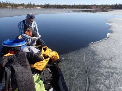
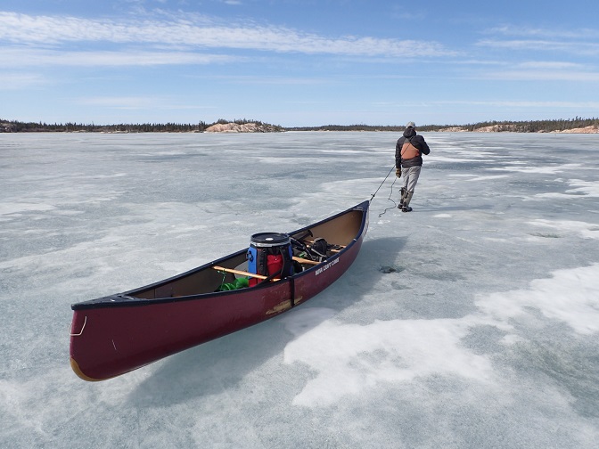
Mike Palmer (WIRL PhD candidate) sampling at Lower Martin Lake. Mike is the lead researcher on this project.