
Motion and deterioration of ice islands represented in the Canadian Ice Island Drift, Deterioration and Detection (CI2D3) Database. These ice islands are fragments of those that originally calved from the Petermann Glacier in 2008, 2010, 2011 and 2012, as well as from smaller calving events at other northwest Greenland floating ice tongues. The size of the ice island at the time of it’s observation is symbolized by the dot size. Animation courtesy of Greg Crocker.
The Canadian Ice Island Drift, Deterioration and Detection (CI2D3) Database is a joint initiative between the Water and Ice Research Lab (Carleton University, Ottawa, Canada), the University of Stirling (UK), and the Canadian Ice Service (Environment and Climate Change Canada) to digitize and catalogue major ice island calving events in Canadian waters for research purposes.
Ice islands are massive, tabular icebergs which calve from ice shelves and floating glacier tongues. The ability to identify, monitor and predict the drift and deterioration of ice islands is crucial for ice-climatology simulations and mitigating risks to marine navigation and offshore infrastructure.
The CI2D3 Database project seeks to extract pertinent information from available satellite imagery for a geospatial database that can be uitilized for ice island drift and deterioration analyses, remote-sensing detection and model calibration and validation.
Version 1 of the CI2D3 Database, focused on recording ice island observations in eastern Canadian waters after large calving events at the Petermann Glacier in 2008, 2010 and 2012. Thousands of archived RADARSAT-1 and -2 (Canadian Space Agency/MacDonald, Dettweiler and Associates) and Envisat (European Space Agency) synthetic aperture radar images were used to track these ice islands and others originating from northwest Greenland until they were too small to delineate. This manual effort was conducted in ArcMap (ESRI) by operators using custom productivity tools. The relationship between each “parent” ice island and its daughter “child” fragment(s) is captured to permit spatio-temporal studies of drift and fracturing.
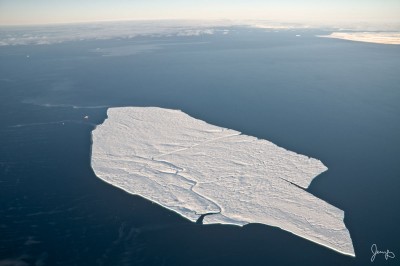
Peterman Ice Island (2010) PII-Ba in Lancaster Sound, October 2011. At the time, this ice island was 3 x 6 km, with a surface area of 12 km2 and a freeboard of approximately 15 m. Photo courtesy of Jessy Barrette.
The CI2D3 Database V1 contains over 25,000 ice island polygons. The CI2D3 project is currently developing V2 of the database, which will incorporate records of ice islands that originated from ice shelves located along the northern coast of Ellesmere Island. This will see the database expand its the spatial coverage into the Arctic Ocean, Beaufort Sea and channels within the Queen Elizabeth Islands.
The CI2D3 Database V1 presented the first systematic account of the drift, fragmentation, and decay of major Arctic ice islands, from their formation to disintegration, at unprecedented spatial and temporal resolution. As the publication list below demonstrates, the database has already been a valuable resource for several research investigations. These research efforts are also of value to investigations and modelling of icebergs in the Southern Ocean, and we expect the database and this associated research to serve as resources for offshore stakeholders, Arctic communities and policymakers.
-
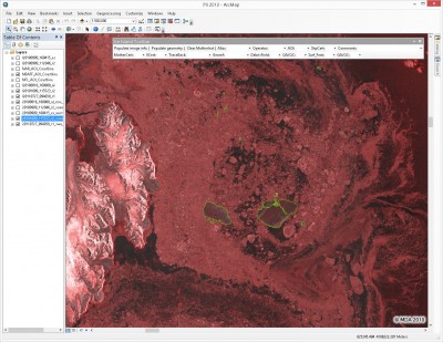
- A screenshot of the digitizing work environment in ArcMap (ESRI) and ice islands (green outlines) in northern Baffin Bay on October 9, 2010. A custom toolbar includes access to the fields required for data entry. Ice island PII-A (74 km2) is on the left while ice island PII-B (right) has just broken into 3 fragments: PII-B (85 km2), PII-B-a (33 km2) and PII-B-b (11 km2). Radarsat-2 data and products © MacDonald, Dettwiler and Associates Ltd., 2010 – All Rights Reserved.

-
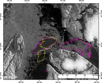
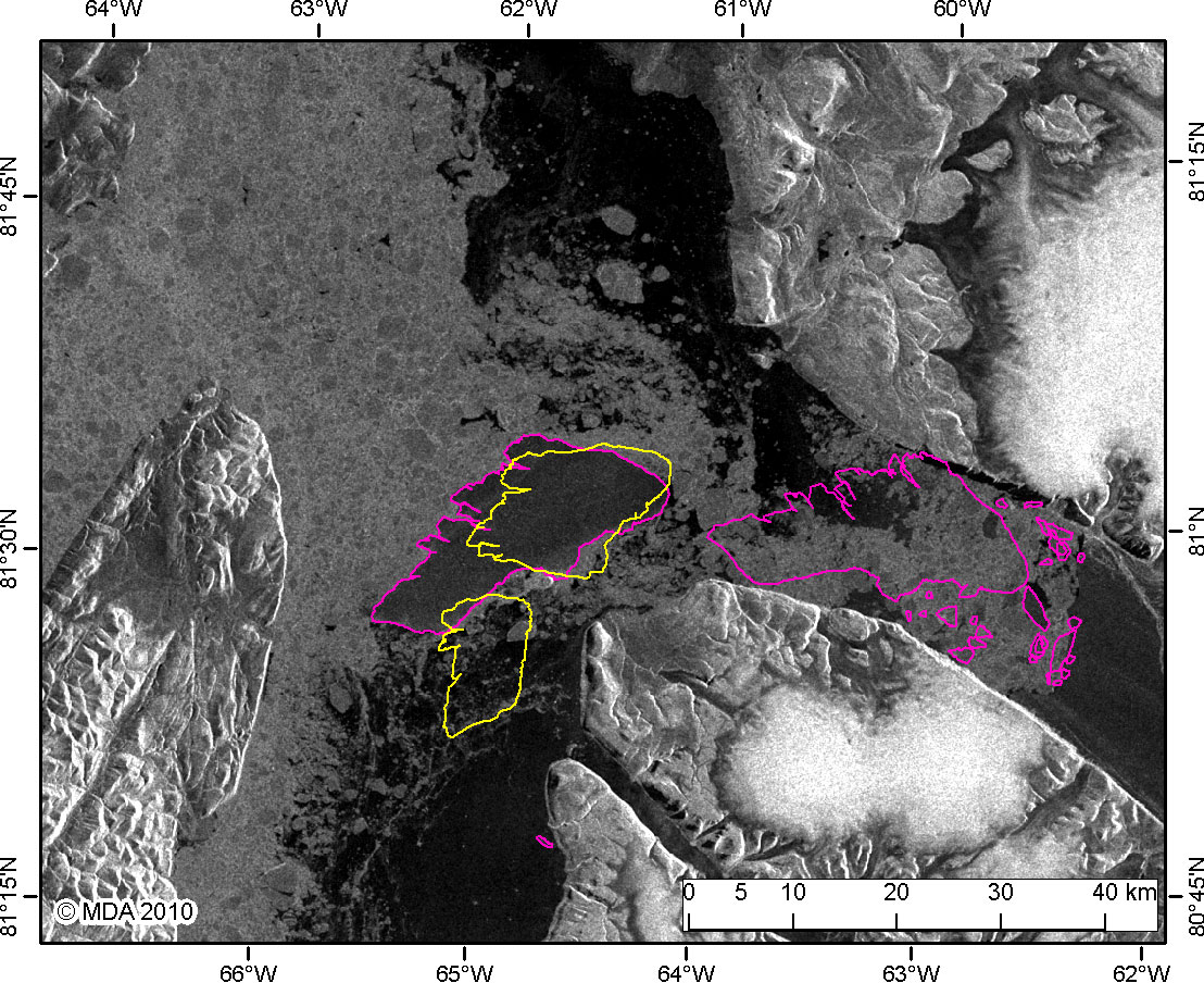
- The original Petermann Ice Island in 2010 (pink), drifted out of Petermann Fiord and broke into two pieces (yellow) on Joe Island in Kennedy Channel, September 9, 2010. The CI2D3 database recorded the relationship between ‘mother’ (PII: 248 km2 as of September 9) and ‘daughter’ fragments, PII-A (85 km2) and PII-B (158 km2) to the south and north, respectively. Radarsat-2 data and products © MacDonald, Dettwiler and Associates Ltd., 2010 – All Rights Reserved.
Explore the CI2D3 Database
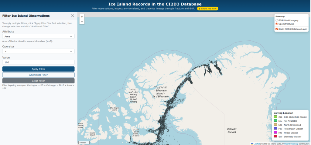
Click on the image to view the CI2D3 data explorer.
For more information
CI2D3 is led by Derek Mueller, a professor at the Geography and Environmental Studies department at Carleton University and Anna Crawford, a Senior Lecturer in Biological and Environmental Sciences at Stirling University, UK.
Downloads & Resources
The data and metadata for this project can be found in the Polar Data Catalogue (Record Number 12678). Releases of new versions of the CI2D3 Database will be hosted on the Polar Data Catalogue and announced on this website. Future releases will be accompanied by updated documentation and a new document of record.
Suggested citation:
Data citation:
Desjardins, L., Crawford, A., Mueller, D., Saper, R., Schaad, C., Stewart-Jones, E., and Shepherd, J. (2018) Canadian Ice Island Drift, Deterioration and Detection Database (CI2D3 Database) [v1.1]. Waterloo, Canada: Canadian Cryospheric Information Network (CCIN). DOI: 10.21963/12678
Document of Record:
Crawford A., Crocker G., Mueller D., Desjardins L., Saper R., and Carrieres T. (2018) The Canadian Ice Island Drift, Deterioration and Detection (CI2D3) Database. Journal of Glaciology 64(245):517-521. DOI: 10.1017/jog.2018.36
Documentation:
Crawford, A., Desjardins, L., Saper, R., Mueller, D., Stewart-Jones, E. 2018. Canadian Ice Island Drift, Deterioration and Detection (CI2D3) Database Documentation [v1.1] Water and Ice Research Laboratory, Carleton University, Ottawa. 19 pp. https://doi.org/10.22215/wirl/2018.1
People and Funding
Contributors to the CI2D3 database include: Derek Mueller, Luc Desjardins, Anna Crawford, Shubham Pawar, Ron Saper, Emilie Stewart-Jones, Jeff Shepherd, Correy Schaad, Gregory Lewis-Paley, Sougal Bouh Ali, Adam Garbo, Eslam Alhogaraty, and students of Advanced Topics in GIS (GEOM 4008) in 2015 and student of Applications in GIS (GEOM 4009) in 2017.
This project was undertaken with the financial support of:




Publications
Crawford, A.J., Crocker, G., Mueller, D., Desjardins, L., Saper, R., and Carrieres, T. (2018) An introduction to the Canadian Ice Island Drift, Deterioration and Detection (CI2D3) Database. Journal of Glaciology 64(245):517-521. DOI:10.1017/jog.2018.36
Crawford, A.J., P. Wadhams, T.J.W. Wagner, A. Stern, E.P. Abrahamsen, I. Church, R. Bates, and K.W. Nicholls. (2016) Journey of an Arctic ice island. Oceanography 29(2):254 – 263. DOI:10.5670/oceanog.2016.30.
Crawford, A.J., Mueller, D., Desjardins, L., Myers, P.G. (2018) The aftermath of Petermann Glacier calving events (2008-2012): Ice island size distributions and meltwater dispersal. Journal of Geophysical Research – Oceans 123. DOI:10.1029/2018JC014388
Zeinali-Torbati, R., Turnbull, I.D., Taylor, R.S., Mueller, D. (2021) A probabilistic model for fracture events of Petermann ice islands under the influence of atmospheric and oceanic conditions. The Cryosphere 15:5601–5621. DOI:10.5194/tc-15-5601-2021
Crawford, A.J., Mueller, D., (2023) Assessing ice island drift patterns, ice island grounding locations, and gridded bathymetry products between Nares Strait and the North Atlantic. ARCTIC. DOI: 10.14430/arctic76227
Marson, J.M., Myers, P.G., Garbo, A., Copland, L., and Mueller, D. (2024) Sea ice-driven iceberg drift in Baffin Bay. Journal of Geophysical Research – Oceans 129:e2023JC020697. DOI: 10.1029/2023JC020697
Crawford, A.J., Crocker, G., Smith, J., Mueller, D., and Wagner, T.J.W. (2024) Evaluating the importance of footloose-type failure in ice island deterioration modeling. Cold Regions Science and Technology 228:104325. DOI: 10.1016/j.coldregions.2024.104325
Dalton, A., Copland, L., Van Wychen, W., Dawson, J., Cook, A., Garbo, A., Mueller, D., and Tivy, A. (2025) Understanding changes in iceberg–ship coexistence throughout the eastern Canadian Arctic: 2012–2019. FACETS 10:1–16. DOI: 10.1139/facets-2024-0232
Smith, J., Mueller, D., Crocker, G., and Sazidy, M. (2025) Evaluation of ice island ‘footloose’ calving events using finite element analysis. Journal of Glaciology 71:e120. DOI: 10.1017/jog.2025.10093
Evans, B.R., Lowe, A.R., Crawford, A., Fleming, A., and Hosking, J.S. (2026) Icebergs, jigsaw puzzles, and genealogy: Automated multi-generational iceberg tracking and lineage reconstruction. The Cryosphere 20:467–482. DOI: 10.5194/tc-20-467-2026