Estimating the amount of water stored as snow in a watershed at the end of winter
The Snare River watershed is located approximately 200 km north of Yellowknife, Northwest Territories, Canada. The watershed drains into a reservoir that is connected to a series of hydro-generation plants. The hydro-plants, operated by the Northwest Territories Power Corporation (NTPC), generate more that 50% of all the electricity used in the entire territory. The Snare River watershed lies right on the treeline. The southern half of the watershed is covered by sparse forests of spruce, larch, and birch, while the northern half is mainly open tundra covered by low shrubs. The entire area is almost 14,000 km2, an area more than double the size of Prince Edward Island. Located within the watershed are thousands of lakes and ponds as well as rivers, huge swamps and bogs, eskers, rolling hills and rocky cliffs. A small indigenous community, Wekweètì, is also locate within the watershed. Being so remote there are no roads to access almost anywhere in the area and all work must be done by ski-plane and helicopter.
Each spring, the snowmelt fills the reservoir and is used for power generation. Rainfall in the area is relatively low meaning that the spring melt is the most significant source of water for the year. Knowing the amount of water likely to flow into the reservoir in the spring allows the NTPC to plan for the coming season. In a more general sense knowing the amount of water stored as snow in a watershed is important for studying permafrost, the ecology and hydrology of the watershed, and is a critical factor in predicting spring floods.
Over the course of a winter snow falls in different amounts across an area. Some of it falls on trees and sublimates back into the atmosphere, some of it falls on open lakes and rivers and melts immediately. Once one the ground it can get redistributed by the wind, sublimated into the air, or melt. To measure the amount of water it is important to understand where to measure and how many measurements are needed to have an acceptable level of confidence in your estimate.
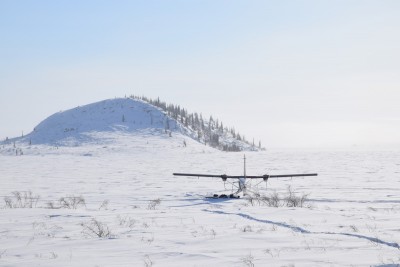
A Twin-Otter with skis on Mesa Lake. Most of the surrounding area is flat, treeless, and covered by shrubs just sticking out above the snow. In the distance a small patch trees can be seen on the southern facing slope of a hill. (Photo: Derek Tokarski)
The answer to the questions of where to measure and how often, changes depending on the landscape. For instance, the snow cover properties in the forested regions are relatively consistent and uniform across 1000’s of square kilometres. Snow properties in the tundra however can vary greatly over short and long distances. At each site we land we take hundreds of depth measurements with an automated probe. Snow depth varies much more than snow density and requires many more measurements. At each site we also take as many density measurements as time allows. Density measurements are done by weighing the snow. A density measurements can take up to 25 times as long as a depth measurement. Balancing the ratio between the measurements is an important factor in optimizing the time spent sampling.
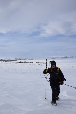
Measuring snow depth and GPS position with a “Magnaprobe”. (Photo: Derek Tokarski)
In addition to predicting spring water levels, changes in the end-of-year water storage could also be a signal of climate change. If we detect changes in water storage, snow depth or snow density on a landscape it may be an indication of changes in wind patterns, temperature, or the type, height, and density of vegetation.
Support, partnerships and collaborations
Essential funding, support, and equipment for this project was provided by the Natural Sciences and Engineering Research Council of Canada, the Cumulative Impact Monitoring Program of the Government of the Northwest Territories (GNWT), the Northwest Territories Power Corporation, the Water Resources Division of the GNWT, and the Department of Geography and Environmental Studies at Carleton University.
Page content by: Derek Tokarski