Ice island and iceberg tracking
Arctic ice islands calve from ice shelves and ice tongues – especially the ice shelves of Ellesmere Island and Greenland’s Petermann Glacier. Since 2007 we have been tracking ice island drift trajectories with satellite tracking beacons. We also have tracked smaller ice island fragments and non tabular icebergs. The Canadian Ice Service and their parent organization, Environment and Climate Change Canada, has helped by supplying most of these beacons and funding for deployment. Other organizations have helped out as well, including Polar Continental Shelf Program, ArcticNet, C-CORE, Statoil and Canatec. Beyond learning where they drift, trajectories can be used to develop and validate drift models that the Canadian Ice Service or we are working on. Collectively, these beacon trajectories can also show patterns over space and time – when and where these ice hazards drift, which is relevant to planning marine transportation routes and infrastructure (see figure below). These beacon drift trajectories complement the data we are collecting for the Canadian Drift, Deterioration and Detection (CI2D3) database.
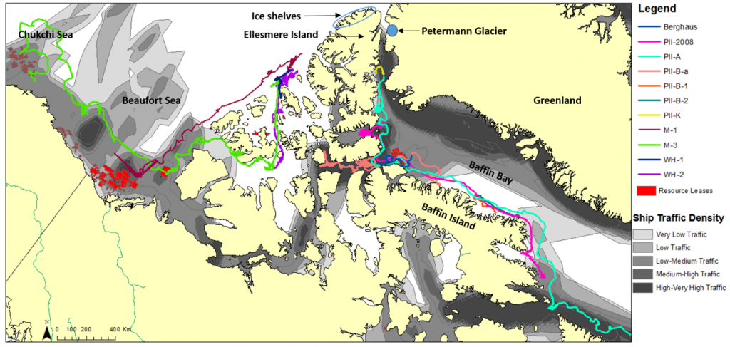
Overlap between ice island drift trajectories, U.S. and Canadian oil and gas exploration lease blocks and ship traffic density. Legend abbreviations are as follows: PII = Petermann Ice Island, M = Markham, and WH = Ward Hunt. Shapefiles of oil and gas leases are courtesy of the U.S. Bureau of Ocean Energy Management (BOEM, 2013) and Aboriginal Affairs and Northern Development Canada (AANDC, 2013). Ship traffic data accessed from exactEarth Ltd. (exactEarth, 2013). Figure taken from the forthcoming ArcticNet Integrated Regional Impact Studies (IRIS) report.