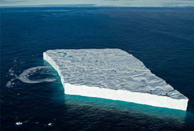
Ice Island Research Projects
Ice islands (immense tabular-shaped icebergs) calve from ice shelves and ice tongues in northwest Greenland and northern Ellesmere Island. As they drift freely in the ocean they can make their way southwards where they are often viewed as hazards to navigation and offshore infrastructure. They also deteriorate over time and may produce numerous, smaller ice hazards (i.e., icebergs, bergy bits and growlers). Ice islands and icebergs also transport large amounts freshwater far from their origin and upon deterioration this freshwater will affect the physical, chemical and biological nature of the surrounding ocean waters. At WIRL, we study the deterioration of ice islands and icebergs, their drift trajectories, their influence on the ocean around them and how they can best be detected in satellite imagery.
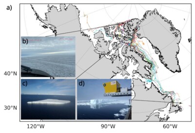
Together with our partners at the Canadian Ice Service and many generous contributors of track data, we built a database of 224 beacon tracks which can be downloaded and used by the iceberg research community.
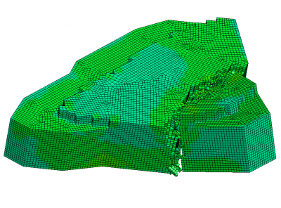
We are developing a model to evaluate catastrophic failures in ice islands that cause them to fracture. This model uses Finite Element Analysis (FEA) to calculate stress across the 3d shape of an ice island to predict fracturing (calving) behaviour. We are using ice island keel and sail shapes surveyed by multibeam sonar, LiDAR and photogrammetry over several field excursions to test and validate the model.
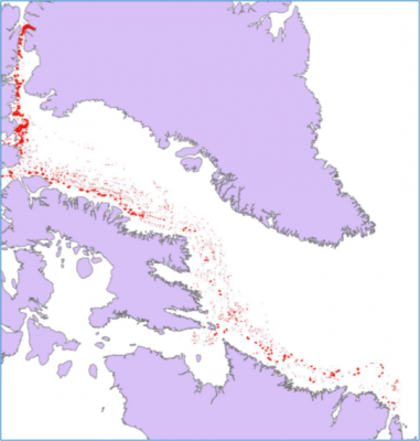
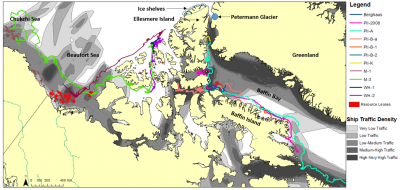
A geospatial ice island database is now been created using RADARSAT-1 and -2Radarsat-2 and ENVISAT imagery from the Canadian Ice Service and European Space Agency image archives. This database has the potential to contribute to at least four areas of ongoing active research, including: drift analyses (statistical approach), deterioration analyses, remote-sensing detection and, drift and deterioration model calibration and validation. Operators are digitizing thousands of ice island polygons from these images and also tracing the lineage of ice island fragments originating from, for now, Petermann Glacier calving events which created immense ice islands in 2008, 2010 and 2012. After digitization is complete for ice islands in the eastern Canadian Arctic and sub-Arctic regions, work will continue to build the database with western Canadian Arctic ice islands.
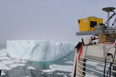
A field program was carried out in April 2015 to test the precision of three iceberg surveying methods for icebergs and ice islands. This included the use of multibeam sonar for keel (underwater) mapping as well as laser scanning and aerial photogrammetry for the mapping of iceberg sails (above-water). The minimum threshold of deterioration which must occur before it can be detected by a particular technique will equate to the error or uncertainty of that surveying method. This precision testing, or error calculation, will be conducted with point clouds generated from consecutive surveys of the same ice feature, over which time deterioration should not have occurred. Each method can then be utilized to collect future deterioration data-sets with multiple surveys of a single iceberg over longer time duration.
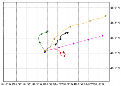
We are engaged in modelling the drift trajectories of icebergs and ice islands. We are using two types of models – a deterministic approach and as well a ‘statistical’ model that incorporates observations of ocean currents taken from drift trajectories. Modelling drift is challenging because of the often chaotic behaviour of ocean currents. Ocean models that are used to drive drift models are not able to capture current eddies at the scale that icebergs and ice islands experience.
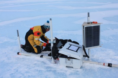
The priority field work consisted of deploying two systems: an ice penetrating radar (IPR) and a meteorological station. The former collects daily thickness measurements, while the latter records hourly air and ice temperature, surface melt (with a sonic ranger) and location. A camera is also installed and programmed to capture a weekly image of the IPR for remote monitoring of its physical set-up. The concurrent data-sets of thickness change and surface melt will result in first continuous, in-situ monitoring of an ice island’s mass balance within the Canadian Arctic.
We track the drift trajectories of ice islands and icebergs using small satellite tracking beacons that we deploy by icebreaker, plane and helicopter. The data help develop models or characterize how fast and far these ice hazards drift.
A study of a grounded iceberg near Resolute Bay in 2014 examined the physical, chemical and biological properties of the adjacent ocean. We discovered that the influence of the iceberg was not detectable but there was a high algal biomass at a certain depth in the ocean that was unusual, which was likely related to a previous bloom under sea ice.
A study of several ice islands in the Arctic to map their sidewalls and underside, plus gather data on their drift and deterioration